Cabo Sportfishing Magazine · Reference guide
Baja California Sur Fishing Banks: Maps from Cabo to Mag Bay and the Sea of Cortez
By Arturo Chacón · Published November 15, 2026 · Updated November 15, 2026
Baja California Sur’s offshore fishing grounds span two coasts, from the Golden Gate and San Jaime banks off Cabo San Lucas to Thetis Bank and the high spots of the Ridge off Magdalena Bay. Across the peninsula, the Gordo Banks and El Bajo de Espíritu Santo are distinct grounds in the Sea of Cortez. This guide shows where these names fit, what kind of structure they describe, and where local fishing reports and charts can tell us more.
What anglers mean by a fishing bank
A fishing bank is a shallower area of seafloor — a plateau, high spot or rise — where the bottom comes up from the surrounding depths. Currents push against that structure, bait gathers over it, and predators follow, which is why fleet reports name individual banks instead of open water. This guide also includes named ridges, seamounts, knolls and offshore spots, because captains and charts use those names the same way: a seamount is an undersea mountain, a knoll a smaller one, a ridge an elongated chain, and names like the 95 Spot or 1150 are fleet shorthand for offshore areas.
Index of named banks and grounds
Every name below is backed by the source cited in its entry. Some sources establish only a broad region, not exact coordinates; outstanding details are listed at the end. This is not a navigation chart.
- Morgan BankLos Cabos Pacific and Lower Banks · Bank (Lower Banks)
- Potato BankLos Cabos Pacific and Lower Banks · Bank (Lower Banks)
- Petrel BankMagdalena Bay, López Mateos and The Ridge · Bank (chart name)
- Toussaint BankLos Cabos Pacific and Lower Banks · Bank (reported Lower Banks high spot)
- Golden Gate BankLos Cabos Pacific and Lower Banks · Bank
- San Jaime BankLos Cabos Pacific and Lower Banks · Bank
Aliases: Jaime Bank
- Finger BankLos Cabos Pacific and Lower Banks · Bank
- Gordo BanksSan José del Cabo and East Cape · Banks (two high spots)
Aliases: Wahoo Banks, Inner Gordo, Outer Gordo
- ImánSan José del Cabo and East Cape · Bank / structure area
Aliases: Iman Bank
- San LuisSan José del Cabo and East Cape · Bank / structure area
- CardónSan José del Cabo and East Cape · Reported fishing area
- La FortunaSan José del Cabo and East Cape · Reported fishing area
- VinoramaSan José del Cabo and East Cape · Reported fishing area
- 1150San José del Cabo and East Cape · Named offshore ground
Aliases: 11:50, 1150 Bank
- 95 SpotSan José del Cabo and East Cape · Named offshore ground
Aliases: The 95
- Cabrillo SeamountOffshore features east of Cabo · Seamount
- Alarcón SeamountOffshore features east of Cabo · Seamount
- Ulloa KnollOffshore features east of Cabo · Knoll
Aliases: Ulloa Seamount
- Thetis BankMagdalena Bay, López Mateos and The Ridge · Bank (Ridge high spot)
- Uncle Sam BankMagdalena Bay, López Mateos and The Ridge · Bank (Ridge high spot)
- 23 Fathom SpotMagdalena Bay, López Mateos and The Ridge · Bank (Ridge high spot)
Aliases: Fathom-23 Bank
- 13 Fathom SpotMagdalena Bay, López Mateos and The Ridge · Bank (Ridge high spot)
Aliases: 13 Bank
- Pistol 38Magdalena Bay, López Mateos and The Ridge · Bank (operator-listed)
Aliases: Pistol-38 Bank
- Juggs BankMagdalena Bay, López Mateos and The Ridge · Bank (operator-listed)
- Alijos RocksNorthern BCS Pacific · Offshore rocks
- El Bajo de Espíritu SantoLa Paz and Espíritu Santo · Seamount
Aliases: El Bajo Marisla, EBES
- El CharroLa Paz and Espíritu Santo · Seamount (chart name)
Aliases: El Charro Seamount
- 110 BajoMulegé, Santa Rosalía and San Marcos · Bajo (chart name)
- The HaystackMulegé, Santa Rosalía and San Marcos · Regional fishing ground (chart name)
- Punta Azul CurveMulegé, Santa Rosalía and San Marcos · Regional fishing ground (chart name)
Los Cabos Pacific and Lower Banks
The Pacific side of the cape holds the banks most visiting anglers hear about first. A historical Los Cabos chart from The Baja Catch marks Golden Gate Bank 24 nautical miles out and Jaime Bank 22 nautical miles out, both labeled for marlin; the SatFish Los Cabos / East Cape map covers the same water today. The labels from that historical chart are listed below as text so they can be read without the image.
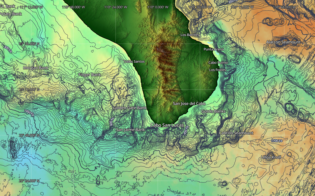
Cabo fishing banks map: the historical chart labels
The SatFish screenshot above is a separate map from the historical Los Cabos chart in The Baja Catch. The following distances and fishing labels come from that historical chart, not from the SatFish screenshot:
- Golden Gate Bank — 24 nautical miles out, labeled for marlin
- Jaime Bank — 22 nautical miles out, labeled for marlin
- Gordo Banks — off Punta Gorda, with striped marlin, wahoo and marlin labels
- Punta Gorda, Cabo Falso, San José del Cabo and Cabo San Lucas as reference points
- Depths in fathoms and a “National Marine Reserve Around Harbor — No Fishing Or Spearing” notice
Historical Los Cabos fishing map (archived Mexfish page, from The Baja Catch by Kelly & Kira)
Morgan Bank
- Feature type:
- Bank (Lower Banks)
- Where it is:
- On Baja California Sur’s Pacific side, in the Lower Banks grounds. Baja Directions includes Morgan in its Mag Bay Offshore chart inventory; the supplied SatFish screenshot labels it west of Todos Santos. These establish regional context, not a verified waypoint or distance from port.
- Documented fishing activity:
- Western Outdoor News included Morgan among Lower Banks high spots with yellowfin-tuna activity in its December 21, 2021 report. This is historical reporting, not current conditions or a catch guarantee.
Potato Bank
- Feature type:
- Bank (Lower Banks)
- Where it is:
- A Pacific-side Lower Banks ground included in Baja Directions’ Mag Bay Offshore chart inventory and named in Western Outdoor News’ Lower Banks coverage. Its label is near the clipped northwest edge of the supplied SatFish screenshot, so that image alone cannot establish its full position. Exact coordinates and port distances remain unverified.
- Documented fishing activity:
- Western Outdoor News named Potato among Lower Banks high spots with yellowfin-tuna activity on December 21, 2021. The dated report does not establish present-day fishing conditions.
Toussaint Bank
- Feature type:
- Bank (reported Lower Banks high spot)
- Where it is:
- A Lower Banks high spot on Baja’s Pacific side, named alongside Potato, Morgan and Golden Gate in Western Outdoor News’ December 21, 2021 long-range report. The source establishes the regional group, not a precise position; coordinates, distances and its relation to The Ridge remain unverified.
- Documented fishing activity:
- That December 2021 report includes Toussaint among high spots with yellowfin-tuna activity. It is historical evidence, not a current report or proof of a recurring season.
Golden Gate Bank
- Feature type:
- Bank
- Where it is:
- Pacific side, northwest of Cabo San Lucas. The historical Los Cabos chart marks it 24 nautical miles out and labels it for marlin.
- Typical departure:
- Usually Cabo San Lucas, according to the LosCabos.fishing grounds guide.
- Documented fishing activity:
- The LosCabos.fishing guide associates Golden Gate with bait concentrations and striped-marlin reports, especially in cooler-season fishing, with tuna and other pelagics in the wider area. It also cautions that the bank is a starting point for a search, not a permanent aggregation.
San Jaime Bank
Also known as: Jaime Bank
- Feature type:
- Bank
- Where it is:
- Pacific side, west of Cabo San Lucas. The historical chart marks “Jaime Bank” 22 nautical miles out, labeled for marlin.
- Typical departure:
- Usually Cabo San Lucas, according to the LosCabos.fishing grounds guide.
- Documented fishing activity:
- LosCabos.fishing describes San Jaime as a separate Pacific bank from Golden Gate; fleet reports often mention both when describing a wider marlin or tuna search, and boats may work the surrounding water rather than sit on the high spot.
Finger Bank
- Feature type:
- Bank
- Where it is:
- A distant Pacific ground north of Cabo, beyond the normal range of many Cabo charters.
- Documented fishing activity:
- LosCabos.fishing cites the Pisces fleet’s figures for Finger Bank: 51 miles away and roughly a two-hour outward ride on that operator’s standard vessels — that operator’s numbers, not a promise for every boat.
San José del Cabo and East Cape
Northeast of San José del Cabo, the Sea of Cortez side holds the Gordo Banks and a string of named grounds that the Puerto Los Cabos fleets work toward the East Cape. Local reports name Imán, San Luis, Cardón, La Fortuna and Vinorama, and use shorthand like the 95 Spot and 1150 for offshore water.
Where are the Gordo Banks?
The Gordo Banks are off the San José del Cabo coast, on the Sea of Cortez side of the cape, and are usually reached from Puerto Los Cabos. The Inner Gordo and Outer Gordo are two separate high spots; local fleets also call them the Wahoo Banks.
Gordo Banks
Also known as: Wahoo Banks, Inner Gordo, Outer Gordo
- Feature type:
- Banks (two high spots)
- Where it is:
- Off the San José del Cabo coast on the Gulf / Sea of Cortez side. LosCabos.fishing describes the Inner Gordo and Outer Gordo as separate high spots; until separate positions are corroborated, this guide uses the collective Gordo Banks label, as the sources do.
- Typical departure:
- Often approached from Puerto Los Cabos. Gordo Banks Pangas, based at La Playa in San José del Cabo, says its launching area is about 10 miles from the banks.
- Documented fishing activity:
- Gordo Banks Pangas says the Gordo Banks are locally referred to as the “Wahoo Banks”. Its dated reports describe tuna, wahoo, dorado and billfish activity around the banks and the grounds to the north.
Imán
Also known as: Iman Bank
- Feature type:
- Bank / structure area
- Where it is:
- Gulf-side coast northeast of San José del Cabo, among the grounds the San José fleets report toward the East Cape.
- Documented fishing activity:
- Gordo Banks Pangas lists Imán among its northern grounds, and its May 3, 2026 report says boats focused on Vinorama, San Luis and Imán for yellowfin tuna and bottom species that week.
San Luis
- Feature type:
- Bank / structure area
- Where it is:
- Gulf-side coast northeast of San José del Cabo, in the same reported string of grounds as Imán and Vinorama.
- Documented fishing activity:
- The May 3, 2026 Gordo Banks Pangas report describes bottom action on rock pinnacles at Vinorama and San Luis, with grouper, amberjack and snapper earlier that week.
Cardón
- Feature type:
- Reported fishing area
- Where it is:
- North of the Gordo Banks toward the East Cape, per the Gordo Banks Pangas grounds list.
La Fortuna
- Feature type:
- Reported fishing area
- Where it is:
- Gulf-side coast northeast of San José del Cabo; LosCabos.fishing groups it with Imán among the names heard in San José fleet reports.
Vinorama
- Feature type:
- Reported fishing area
- Where it is:
- Toward the East Cape; Gordo Banks Pangas says its charters have the range to cover the areas from Cabo San Lucas to Vinorama.
- Documented fishing activity:
- The May 3, 2026 Gordo Banks Pangas report describes yellowfin tuna and bottom fishing at Vinorama, with the best bottom action on jigs over rock pinnacles.
1150
Also known as: 11:50, 1150 Bank
- Feature type:
- Named offshore ground
- Where it is:
- Offshore water on the Gulf-side approach, per LosCabos.fishing, which notes the name is local shorthand also written 11:50 and that chart labels can differ from fleet shorthand.
- Documented fishing activity:
- The May 3, 2026 Gordo Banks Pangas report says the best marlin action that week was reported at the 1150 Bank and its surrounding areas. Tag Cabo’s reports page lists the 1150 Bank among Cabo San Lucas-side grounds.
95 Spot
Also known as: The 95
- Feature type:
- Named offshore ground
- Where it is:
- Offshore water worked by Cabo San Lucas fleets; Tag Cabo’s reports page lists the 95 Spot among Cabo San Lucas-side grounds alongside the 1150 Bank and Golden Gate.
Offshore features east of Cabo
The official undersea-feature gazetteers name three features in the deep water east and southeast of Cabo San Lucas. They appear on charts as map references; we add fishing profiles only where fishing activity is documented, and none is documented for these three yet.
Cabrillo Seamount
- Feature type:
- Seamount
- Where it is:
- The IHO-IOC GEBCO gazetteer lists Cabrillo Seamount at 22°50′N, 109°15′W in the North Pacific, offshore southeast of Cabo San Lucas.
Alarcón Seamount
- Feature type:
- Seamount
- Where it is:
- Marine Regions lists Alarcón Seamount at 23°37′N, 108°45′W inside the Gulf of California, with the name from the US BGN Advisory Committee on Undersea Features.
Ulloa Knoll
Also known as: Ulloa Seamount
- Feature type:
- Knoll
- Where it is:
- The GEBCO gazetteer lists Ulloa Knoll at 22°35′N, 108°55′W, offshore east of Cabo San Lucas; the US BGN committee records the same feature as Ulloa Seamount.
Magdalena Bay, López Mateos and The Ridge
Off Magdalena Bay, a long seamount chain known to fleets as The Ridge holds the best-known high spots of Baja’s Pacific side, including Thetis Bank and Uncle Sam Bank. Published accounts define The Ridge differently — BDOutdoors describes a 50-mile seamount with four prominent high spots, while a local operator describes a 35-mile ridge with six — so this guide does not state a single definitive length.
What is Thetis Bank?
Thetis Bank is a named high spot on The Ridge, the seamount chain off Magdalena Bay on Baja’s Pacific side. A local operator says wahoo and tuna are most commonly found there, and SatFish names it among the striped marlin grounds off Magdalena Bay.
Petrel Bank
- Feature type:
- Bank (chart name)
- Where it is:
- A named offshore bank in Baja Directions’ Mag Bay Offshore chart coverage of the Bahía Magdalena region. The public chart description corroborates the name and regional coverage, but does not provide Petrel’s coordinates or establish that it is part of The Ridge. Its precise position, departure port and fishing activity remain unverified here.
Thetis Bank
- Feature type:
- Bank (Ridge high spot)
- Where it is:
- Off Magdalena Bay on the Pacific side, one of the named high spots along The Ridge. SatFish describes the striped marlin grounds off Magdalena Bay, “like the Ridge and Thetis Bank”, as part of its Baja Pacific South coverage.
- Documented fishing activity:
- The Sport Fishing Mag Bay operator account says wahoo and tuna are most commonly found at Thetis Bank, and that Thetis becomes the area of choice when the sardines are still to the north. BDOutdoors counts Thetis Bank among The Ridge’s four prominent high spots.
Uncle Sam Bank
- Feature type:
- Bank (Ridge high spot)
- Where it is:
- The northern end of The Ridge’s named high spots off Magdalena Bay.
- Documented fishing activity:
- The operator account says the main marlin fishing zone stretches between the northern point of Uncle Sam Bank and a point just south of Punta Tosca. BDOutdoors also lists Uncle Sam Bank among the four prominent high spots.
23 Fathom Spot
Also known as: Fathom-23 Bank
- Feature type:
- Bank (Ridge high spot)
- Where it is:
- One of The Ridge’s named high spots off Magdalena Bay.
- Documented fishing activity:
- The operator account names the 23 Fathom Spot among its top spots for marlin, yellowtail and dorado; BDOutdoors lists it among the four prominent high spots.
13 Fathom Spot
Also known as: 13 Bank
- Feature type:
- Bank (Ridge high spot)
- Where it is:
- One of The Ridge’s named high spots off Magdalena Bay.
- Documented fishing activity:
- BDOutdoors’ December 2022 account describes fishing the 13 Fathom Spot in early November, with skipjack and yellowfin tuna working over the bank.
Pistol 38
Also known as: Pistol-38 Bank
- Feature type:
- Bank (operator-listed)
- Where it is:
- Listed by the Sport Fishing Mag Bay operator among The Ridge’s high spots; the name is attributed to that operator and is kept distinct from the core inventory.
- Documented fishing activity:
- The same operator account names Pistol 38 among its top spots for marlin, yellowtail and dorado.
Juggs Bank
- Feature type:
- Bank (operator-listed)
- Where it is:
- Listed by the Sport Fishing Mag Bay operator among The Ridge’s high spots; the name is attributed to that operator and is kept distinct from the core inventory.
Northern BCS Pacific
Farther up the Pacific coast, SatFish’s Baja Pacific South map displays the water from Abreojos to the Lower Banks, including Alijos Rocks. The named-bank inventory for the Punta Abreojos, Bahía Asunción, Bahía Tortugas and Isla Natividad region is being expanded as we verify local names.
Alijos Rocks
- Feature type:
- Offshore rocks
- Where it is:
- An offshore feature within SatFish’s Baja Pacific South coverage, which displays the water from Abreojos to the Lower Banks.
La Paz and Espíritu Santo
Off La Paz, El Bajo de Espíritu Santo is the best-documented seamount in the southern Gulf of California: it appears in the official management program of the Espíritu Santo Archipelago protected area and in oceanographic research. Access and activity rules come from the official zoning, not from fleet custom.
El Bajo de Espíritu Santo
Also known as: El Bajo Marisla, EBES
- Feature type:
- Seamount
- Where it is:
- About 9 nautical miles northeast of Isla Espíritu Santo, according to the official management program, which describes El Bajo as an undersea mountain inside the protected area’s buffer zone. The 2010 Bitácora del Mar Profundo expedition devoted a chapter to it under the name Marisla, and oceanographic literature cites it as the EBES (Bajo Espíritu Santo) seamount off Bahía de La Paz.
- Documented fishing activity:
- The management program describes El Bajo as an upwelling site that favors reproductive and nursery aggregations of pelagic and reef species, and places it in a sustainable-use subzone (“Aprovechamiento Sustentable de los Recursos Naturales 2 El Bajo”). Any access or activity statement for this feature comes from that official zoning.
El Charro
Also known as: El Charro Seamount
- Feature type:
- Seamount (chart name)
- Where it is:
- A separately documented feature in the La Paz fishing area; the Baja Directions La Paz chart lists “El Charro Seamount” among its highlighted fishing areas off Isla Espíritu Santo and Isla Cerralvo.
Loreto and the islands
The waters around Coronado, Carmen, Danzante, Montserrat and Catalana islands lie inside Bahía de Loreto National Park, which has an official management program. Our bank index stays open for locally verified names here, and any future entry will be checked against the park’s zoning before publication.
Mulegé, Santa Rosalía and San Marcos
In the central Gulf, the Baja Directions Mulegé chart names fishing areas accessible from Santa Rosalía, San Lucas Cove, Punta Chivato, Bahía Concepción and Mulegé, including the 110 Bajo off Isla San Marcos, the Haystack and the Punta Azul Curve at Isla Tortuga.
110 Bajo
- Feature type:
- Bajo (chart name)
- Where it is:
- Off the north tip of Isla San Marcos, per the Baja Directions Mulegé chart.
The Haystack
- Feature type:
- Regional fishing ground (chart name)
- Where it is:
- Just north of San Lucas Cove, per the Baja Directions Mulegé chart.
Punta Azul Curve
- Feature type:
- Regional fishing ground (chart name)
- Where it is:
- At Isla Tortuga, per the Baja Directions Mulegé chart, which calls it “the fabled Punta Azul Curve”.
How to Read a Fishing Bank on SatFish
Take Golden Gate Bank as the example. On a bathymetry view — a shaded-relief map of the seafloor with depth contours — a bank shows as a shallower top: a plateau or high spot where the contour lines crowd together. Around that top, the steeper edges are where the bottom drops off and the contour lines pack tightest. The closer the lines, the faster the depth changes.
From there, a captain can switch on the sea-surface temperature and chlorophyll (water-color) layers. If a temperature break or a color change runs along one edge of the bank, that edge marks where different water masses meet — the first edge worth investigating on the day. SatFish describes its layers as tools for finding temperature breaks, water-color changes, current edges and structure that can concentrate bait and game fish.
The SatFish screenshot in the Los Cabos section shows bathymetry only, not temperature, chlorophyll or currents. No dated conditions-layer image has been supplied. These layers describe water, not the presence of fish, and are not catch forecasts.

Save $20 USD on SatFish
$20 USD OFF
Save $20 USD on SatFish with promo code TAGCABO.
Take your offshore fishing intelligence further with satellite fishing charts, ocean temperatures, chlorophyll, currents and offshore planning tools.
Sponsored by SatFish. Offer subject to SatFish’s eligibility and checkout terms. SatFish charts are a separate commercial service and are not part of the NOAA analysis shown above.
Protected waters and official zoning
Some names in this guide sit inside or beside protected areas, and fleet custom is not the rulebook. El Bajo de Espíritu Santo lies in the buffer zone of the Espíritu Santo Archipelago protected area, with activities set by its official zoning. Cabo Pulmo National Park protects the only coral reef system in the Sea of Cortez; its management program states that, from the park’s official declaration, fishing there was restricted to family consumption. The waters around the Loreto islands are a national park with its own management program. Check the current zoning and permits with the authorities before fishing any protected water.
Editorial follow-up list
The following bank names now have cited regional entries above, but precise locations and other details still need corroboration. No coordinates, depths or distances are inferred from the screenshot.
- Morgan Bank and Potato Bank. Names and Lower Banks context are corroborated and indexed. Exact coordinates, depths and port distances still need an authoritative chart; Potato’s label is near the clipped edge of the supplied SatFish screenshot.
- Petrel Bank and Toussaint Bank. Names and broad regional context are now sourced and indexed. Exact positions and any relationship to The Ridge remain unverified; Petrel’s fishing activity is also unverified.
Sources
- Baja Directions — Mag Bay Offshore chart description (Morgan, Potato and Petrel)
- Western Outdoor News — “Long Range: more lower-banks giants” (December 21, 2021)
- Historical Los Cabos fishing map (archived Mexfish page, from The Baja Catch by Kelly & Kira)
- LosCabos.fishing — Fishing Spots & Grounds guide
- Gordo Banks Pangas — fleet and grounds, Puerto Los Cabos
- Gordo Banks Pangas fishing report, May 3, 2026
- Tag Cabo Sportfishing fishing reports (owner-affiliated fleet)
- IHO-IOC GEBCO Gazetteer of Undersea Feature Names
- Marine Regions — Cabrillo Seamount record
- Marine Regions — Alarcón Seamount record
- Marine Regions — Ulloa Knoll record
- Sport Fishing Mag Bay — offshore fishing account
- BDOutdoors — “The Ridge: An Introduction to One of Baja’s Greatest Fisheries” (Dec 20, 2022)
- SatFish — Baja California fishing map coverage
- DOF — Espíritu Santo Archipelago management program (official decree)
- Bitácora del Mar Profundo — 2010 Gulf of California expedition book (INECC/COBI)
- Geofísica Internacional (2003) — Influence of EBES seamount and Farallón basin on coastal circulation
- Baja Directions — La Paz fishing chart
- Baja Directions — Mulegé fishing chart